Jewiki unterstützen. Jewiki, die größte Online-Enzy­klo­pädie zum Judentum.

Helfen Sie Jewiki mit einer kleinen oder auch größeren Spende. Einmalig oder regelmäßig, damit die Zukunft von Jewiki gesichert bleibt ...

Vielen Dank für Ihr Engagement! (→ Spendenkonten)

How to read Jewiki in your desired language · Comment lire Jewiki dans votre langue préférée · Cómo leer Jewiki en su idioma preferido · בשפה הרצויה Jewiki כיצד לקרוא · Как читать Jewiki на предпочитаемом вами языке · كيف تقرأ Jewiki باللغة التي تريدها · Como ler o Jewiki na sua língua preferida

Datei:Nile River and delta from orbit.jpg

Aus Jewiki
Zur Navigation springen Zur Suche springen

Nile_River_and_delta_from_orbit.jpg(700 × 550 Pixel, Dateigröße: 85 KB, MIME-Typ: image/jpeg)

Diese Datei stammt aus einem gemeinsam genutzten Medienarchiv und kann von anderen Projekten verwendet werden. Die Beschreibung von deren Dateibeschreibungsseite wird unten angezeigt.

Beschreibung

Beschreibung

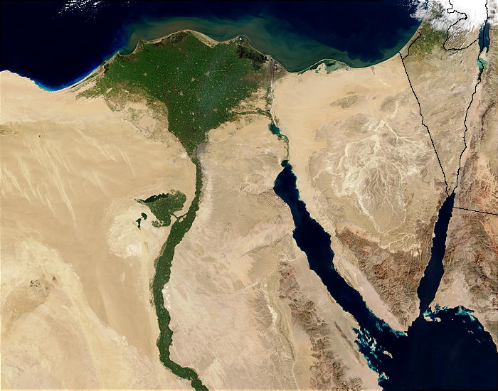
Nile River and delta from orbit Description: The Nile River and delta as seen from space by the MODIS sensor on the Terra satellite.

"Against the barren desert of northeastern Africa, the fertile valley of the Nile River runs northward through Egypt. In the higher-resolution images, the city of Cairo can be seen as a gray smudge right where the river widens into its broad fan-shaped delta. Other cities are dotted across the green landscape, giving it a speckled appearance. Where the Nile empties into the Mediterranean Sea (top) the waters are swirling with color, likely a mixture of sediment, organic matter, and possibly marine plant life. Farther west, the bright blue color of the water is likely less-organically rich sediment, perhaps sand.
"East of the delta lies the arid Sinai Peninsula, whose pointed tip is home to rugged mountains, some as high as 8,600 feet. The lattice work of pale lines marks the paths of ephemeral rivers. The Sinai Peninsula intrudes into the Red Sea. Farther east are Israel, Jordan, and Saudi Arabia. At top right is the disputed territory of the West Bank.
"In the false-color image, vegetation is bright green, water is dark blue or black, and clouds are light blue. It's interesting to notice that places that seem essentially arid, or desert-like in the true-color image in fact have a delicate layer of vegetation. For example, the central Sinai Peninsula, and most of Israel have a faint greenish tinge in the false-color images.
Datum
Quelle http://visibleearth.nasa.gov/view_rec.php?id=4927 [1]
Urheber Jacques Descloitres, MODIS Rapid Response Team, NASA/sh
Andere Versionen Cuaggjacgacugvajgca

Salchicha

Lizenz

Public domain Diese Datei ist gemeinfrei (public domain), da sie von der NASA erstellt worden ist. Die NASA-Urheberrechtsrichtlinie besagt, dass „NASA-Material nicht durch Urheberrecht geschützt ist, wenn es nicht anders angegeben ist“. (NASA-Urheberrechtsrichtlinie-Seite oder JPL Image Use Policy).
Warnung:

Kurzbeschreibungen

Nildelta

In dieser Datei abgebildete Objekte

Motiv

image/jpeg

86.876 Byte

550 Pixel

700 Pixel

770cb4720dbd887a6e7888a523804efc446bafd8

Dateiversionen

Klicke auf einen Zeitpunkt, um diese Version zu laden.

Version vomVorschaubildMaßeBenutzerKommentar
aktuell23:47, 29. Nov. 2004Vorschaubild der Version vom 23:47, 29. Nov. 2004700 × 550 (85 KB)commonswikimedia>MschlindweinNile River and delta from orbit

Die folgende Seite verwendet diese Datei: